(written on February 19th from notes taken previously).
It was a much more eventful day today. 🙃
As I was leaving the car park this morning, a nice young man who had been parked next to me, stopped me just as I was about to drive away, letting me know that my rear passenger tire was super low. 😬
I wondered if maybe it was just a really slow leak, and I just hadn’t noticed, but I really didn’t want to have to break out my scissor jack and figure out how to get my donut out from underneath my van.
So I skipped the caving adventures that I might have been able to do nearby and started driving South toward Greymouth–the only relatively nearby town that I felt like would have the resources necessary to either patch my tire or sell me a new one.
I did stop briefly along the way, hoping to figure out where the leak was coming from, but I wasn’t able to find it.
Gratefully, I found a tire shop that was still open on a Saturday, and they were able to get my tire patched up and get me on my way relatively quickly. Thx, Independent Tyre Services. 🙏
From there, I did a revisit of Cobden Cave, a small, muddy cave just up the hill from Grey River–the large river that acts as a collection for many smaller rivers before emptying out into the Tasman Sea.
I had absolutely zero memory of the inside of the cave from our last trip, so I figured I’d refresh my memory.
I won’t seek a refresh in the future. 😆
As New Zealand caving opportunities go, this is on the list of caves that’s not worth visiting unless maybe you’re a local just to better get to know your own area.
It doesn’t go back very far. It’s muddy and slippery, there’s been at least one cave in, and it’s just… not worth the time or risk, in my opinion.
The next stop was to find a bathroom. Was Micro John full? I don’t remember. 🤔
Whatever the reason for going to find a public bathroom, it turned out to be a little bit of a saga. 😆
I went back across the bridge over the river into town, and then drove down and around to the public restroom near the train station, getting there just as another lady entered.
After what seemed like an eternity of her being inside, she finally left, and I entered, only to find that there wasn’t any toilet paper available (perhaps the reason she had been in there for so long 😅).
For whatever reason, I didn’t just grab toilet paper from my van, instead heading over to the next public toilet opportunity that also turned out to be a bust.
Finally on my third try (third time’s the charm 🙃), I found a restroom next to the police station that I was able to avail myself of. 🙏
And with that, it was time to head back North again, as there were multiple places that I had wanted to visit on my drive south that I hadn’t because I was concerned about making sure I got my tire fixed first.
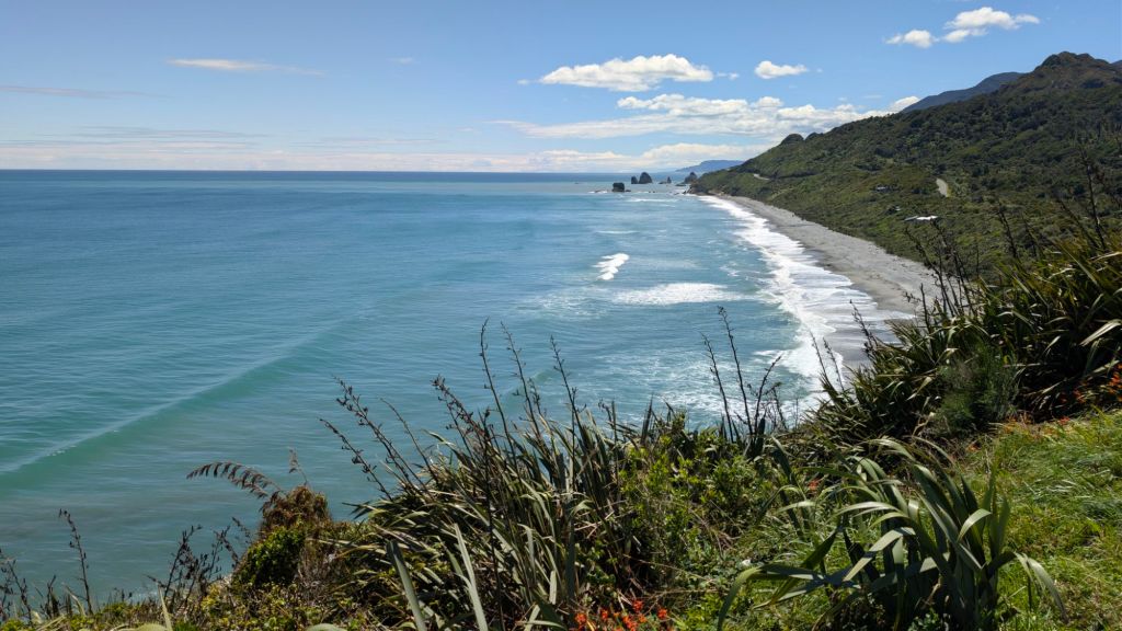
Other than the pictures that I stopped to take of the beautiful scenery along the drive, and the the pin I dropped myself for the location of a pretty hefty trash dump that someone had decided to dump over the side of the cliff down to the beach 😒, my first real stop was to a little dirt pullout off of a sort of u-shaped bend in the coastal highway.
Maybe ‘closed road’ is a better description than ‘dirt pullout,’ as it’s a dirt turn off from the u-shaped bend in the road that ends in a closed gate, so you can’t drive any further.
Officially, the road beyond the gate is listed as Ten Mile Rd, but it’s probably more accurate nowadays to say that it’s 10 Mile Trail.
A bit curious, I decided to start walking up the canyon just to see what was up there. As you well know, I’ve often found fun places when I do that kind of exploring, and today was no exception. 😁
The walk along the road followed a beautiful river, sometimes visible, sometimes obscured by the bush, sometimes further below me, sometimes close to trail level.
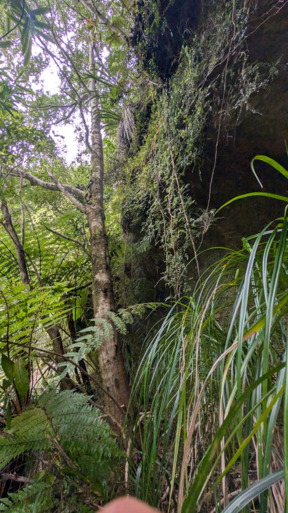
I walked along, listening to podcasts I had downloaded, until off to my right I noticed a little cave!
I didn’t have my headlamp with me, as I wasn’t expecting to run into any caves, so I turned the flashlight on on my cell phone and started walking in.
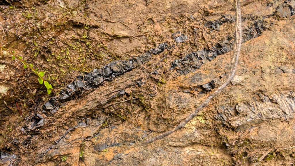
To my surprise, the walls of the cave were not made of rock: They were made of coal. 😲
Coal? Here? Really?
Never would have guessed. 🙃
Unable to really see much of anything inside because of the weakness of my cell phone flashlight (which probably had something to do with the fact that the walls of the cave were black 🙃), I went down only to the point where my next steps were going to have to be in water if I wanted to continue.
Without a decent light source, I figured that probably wasn’t the best idea.
So I exited the cave and continued on up the road, wondering what else I might run into along the way. There was one place along the walk where the side of the road had collapsed down the drop off toward the river, so that’s probably why the road’s been closed to drivers.
It was a beautiful canyon to walk up, the river below, densely vegetated steep hills and cliffs all around.
By and by, I came upon the very large ruins of an old coal mining operation. Lots of ruins, and spread out over quite a distance.
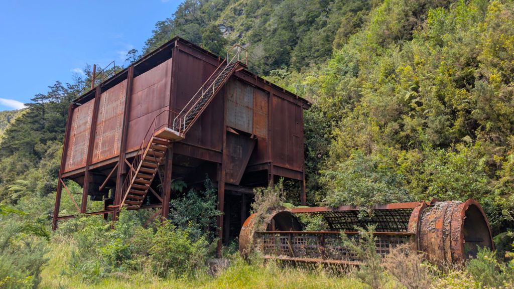
At first, I wanted to try and figure out a way to climb up the ruins to look down into them, but I couldn’t find any way that I felt was even close to reasonably safe, so I gave up and continued walking up the canyon, passing more and more ruins along the trail as well as in the hillsides.
Eventually, after walking quite a ways (I think about a mile and a half or so?), I came to a bunch more mining ruins. At this particular point, the river I had been walking along was now far below me, and I was meeting up with a relatively small tributary, descending the steep canyon to my right.
In this area, the ruins looked a bit like ski lift towers, with heavy duty metal cables running between them and the mangled rusty ruins of coal cable cars that had once traversed the canyon going from tower to tower on their way to the road below.
It was actually pretty cool to be there and explore. 😊
I wanted to keep exploring, so I decided to rock hop up the tributary that went up the steep hill to my right, and then jog off to the right, following the path the large steel cable took through the bush.
The path off to the right actually ended up requiring that I go up a pretty sketchy bouldering section. It wasn’t super steep, just slippery places I needed to avoid and very few good holds, so it was time consuming, requiring a lot of thought and strategy.
It wasn’t super dangerous, though it was a good little ways down if I slipped. But it was the kind of thing where you’d slide down fairly quickly and smack hard into the bottom, but you wouldn’t be going over any cliffs.
Still, I got maybe halfway up before I thought better of it and decided to go off to my left.
Going straight up the draw up to my left had its own challenges, as there wasn’t really any way back to the right without trying to climb straight up, so I sort of gave up on following the cable path and started traversing to the left, back toward the little tributary, just a fair bit higher up than I was before.
There wasn’t any kind of a path, so I was just bush bashing my way back to the little tributary creek.
Once back at the creek, I just kept rock hopping up, up, and up. Sometimes I needed to climb alongside the creek when the boulders in the creek were two large or dangerous to try and scale up.
I thought maybe I would come to a waterfall at some point, but the higher I went, the more it felt like this was one of those alpine creeks that never has a large fall, just cuts through the canyon with little cascades here and there.
After going up a good ways, I decided I had gone up far enough and didn’t really need to explore anymore. So I just sat on the side of the creek and spent some time working on my journal catch-up efforts.
Pretty shockingly, there were pretty much zero sand flies. 😲.
I wasn’t unhappy about that. 🙃
After a fair bit of journaling, I decided to head down (which took a lot longer than I expected because I had gone a lot higher than I thought I had), but as I passed that little precarious bouldering section that I had begun climbing before, my curiosity got the better of me, and I headed back over and back up. 🙃
This time, I put the work in, and took the few risks necessary, to make it to the top of the scramble. 🧗
From there, it got even more precarious–my next obstacle being more of an 80° angle drop off. 😆
At that point in the hike, the steel cables that used to carry the coal cars above were rusting on the ground below. They looked intact, but if you twisted or tried to kink them, metal would begin to disintegrate in your hands.
I tried to find a safe route up the slick, maybe 5 meter? drop off. There were places that I could put my hands and feet on the right side, and I started going up that way to see if I could make it, but it was just… not smart.
Unwilling to give up yet, I decided to see if there was another way around, so I hit it off to the right of the drop off, through the bush until, believe it or not, I came to an aluminum ladder that was propped up against maybe a 10-ft drop off. 😶
Aluminum doesn’t rust, and after giving the ladder a little look over, it seemed sturdy enough, so I went ahead and climbed up the ladder into the bush above.
From there I wound my way through the bush to the next little mini cliff, and that’s where I was… a bit stupid.
And probably lucky. 😅
I had been pretty smart in my calculated risk taking up to that point, but on this section, perhaps a 15 or 20-ft drop, I ended up using hand holds and footholds that… simply weren’t trustworthy.
Had they given out, even just one, I most likely would have tumbled off the drop off landing hard below.
A fall from there very easily could have resulted in severe injury, even death.
Not smart. 😅
And then there was the reality of having to come back down. 😬
As I continued on up, I found more ruins, a cable Cole car that was mostly intact, albeit quite rusted, and more cables going up the steep hillsides.
I gave up on my ascent about that point, and turned my attention to getting back down.
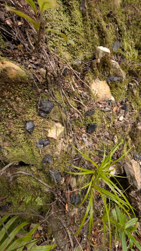
But there was coal absolutely everywhere–on the surface, in the dirt, etc.
I decided not to go back down the cliff I had foolishly climbed up, instead winding my way down through the bush to the right of the cliff (when facing uphill).
Eventually, I came to the same drop off, but even more of a straight drop than the one that I had climbed up. 😆
There was a difference this time, though: there was a tree that began at the base of the drop off perhaps 15 or 20 ft below that grew straight up next to the cliff to where I was and continued well above it.
The catch was that there weren’t very many branches: It was mostly trunk, so you need to squeeze and sort of shimmy down. There was also another problem: The tree was just far enough away from the cliff that you pretty much had to commit to going down via tree if you were going to even touch the tree.
I hemmed and hawed for a little bit. I thought about trying to find another way down, but eventually, I decided that was my best and safest path down.
So I committed. 😅
I leaned forward over the cliff hands resting against the tree, and then I hopped forward giving the tree a hefty bear hug. 😆
Shimmying down the tree turned out to be a heck of a lot easier than I had anticipated. Between the strength of my arms and legs, I was able to shimmy down in complete control.
Going back going back up probably would have been a lot more challenging, but I wasn’t going back up.
Down I shimmied until I got to some branches, and then I was able to down climb a little bit, and eventually, I was able to drop to the ground.
Safe and sound. 🎉
I then, somehow, managed to find my way through the bush right back to the ladder I had climbed up. I didn’t recognize any part of my little journey through the bush from down climbing the tree to the ladder, but boom there I was at the ladder again. 🙏
Once again, I noticed the presence of coal absolutely everywhere. I don’t know if it was just years of coal spilling from the coal cars running along the cables above that then mixed with the rock and soil below (such that it almost looked like a natural part of the sediment layer) or if maybe the coal from smaller seams would break up and form the little chunks I saw all over? Or maybe both?
🤷
The last significant obstacle in my way down was down climbing that large bouldering section that I had gone up. Gratefully, though a little nerve-wracking and a little sketchy, I was able to avoid the slippery spots, find decent enough footholds, and safely down climb without any issue.
🙏
From there, it was just a quick rock hopping jaunt back down the creek to the road, though I went a little further than the road because I thought maybe there was a waterfall below me, because I thought I could perhaps hear the thundering of water crashing into a pool below.
I didn’t go down very far, though, deciding I just wasn’t up for it at this point.
On the walk back, I paid special attention to the hillside of the road in order to catch that little coal mining shaft that I had found before. I was wanting to explore it more thoroughly, but I wanted to be able to measure how far from where my van was parked it was, so I knew whether or not I felt like it was going to be worth it to go all the way back to my van, grab my headlamp, go all the way back to the mine shaft, and then walk all the way back to my van.
Gratefully, I did find the little coal mine shaft once again, but instead of simply measuring the distance from the shaft to the van, I decided to give exploring it with just my cell phone light one last go. 🙃
So on I went inside, going deeper and deeper into the shaft as it sloped gently down.
If I remember correctly, I spent some time with my eyes closed, trying to avoid looking at light in order to better acclimatize to the darkness.
Eventually, I was able to discern that the shaft ended shortly after the water portion that I had reached earlier. It might have gone another 5 meters or so, but it was all water.
There was, however, to the right of the water, another shaft. So I carefully climbed along the side, and up into the other shaft and started exploring that one.
Very quickly, however, I realized that it didn’t go all that far, and nor did it feel very safe. It looked like it had had a previous cave in, so I got myself out of that area relatively quickly, traversed back down and along the side of the water and then headed on out of the cave.
After lots of walking and fewer pictures than I probably should have taken, I was back at my van. 😊
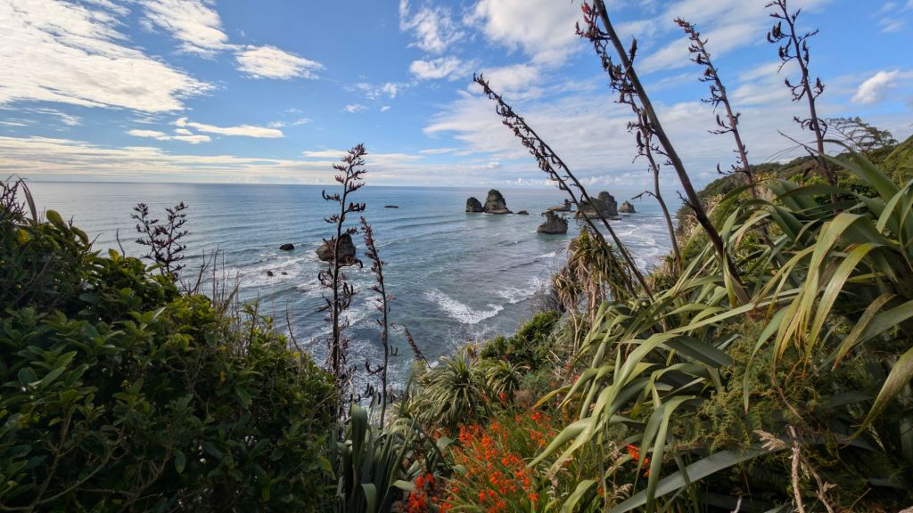
From 10 Mile Road, I continued heading north along the coastal Highway, taking pictures and chatting with my mom a little bit.
I stopped off at the same little spot where, 3 years ago, I had first had the opportunity to swim with dolphins, but they weren’t any visible today.
I did, however, spend a fair bit of time talking on the phone with Kylie, the Australian lady I had met at Kauri Mountain Beach. We’ve kept in touch since, texting back and forth on WhatsApp, but this was the first time that we’d actually talked on the phone.
We chatted for a little while, and then I let her go and wandered down the hill to re-explore Punakaki Caves.
I had gone through them with Chase last time I was in New Zealand, but I didn’t remember them very well, so I went and explored them again.
Cool cave. Great for families and beginners to just sort of walk around in and enjoy, but not much to actually explore.
There definitely were some cool formations, though. 😊
After wandering through Punakaki Caves, I headed over to a spot Chase and I had not visited last time, I think because it was paid parking, and I didn’t want to pay for it? 🙃
I think also because it felt like a big tourist trap with a big visitor center and everything.
This time, I decided to go. I parked my van along the side of the road. Not sure if where I parked was legal or not, but there were other cars parked there, so I joined them. 😅
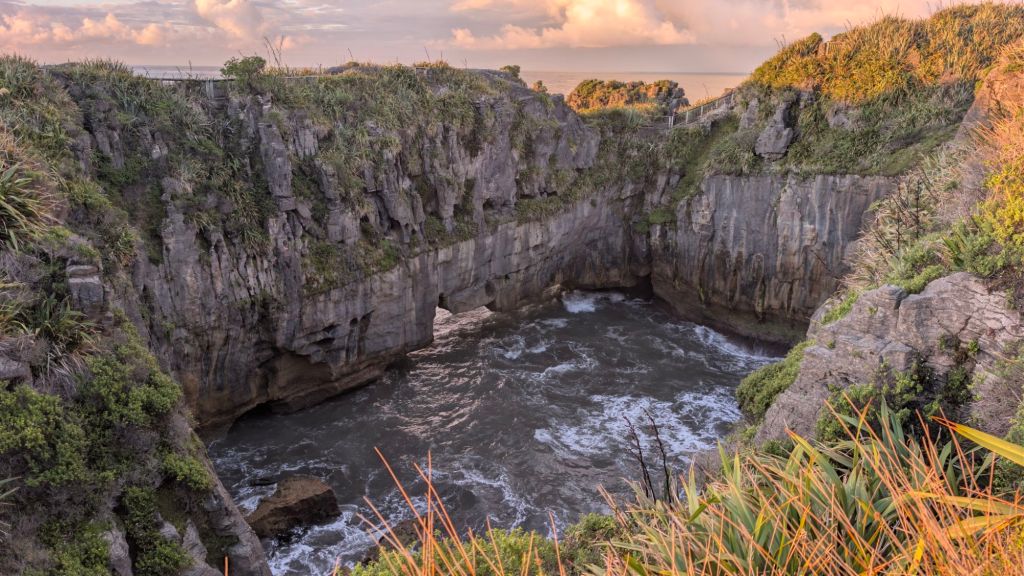
Pancake Rocks turned out to be pretty cool, beauty everywhere. 😊
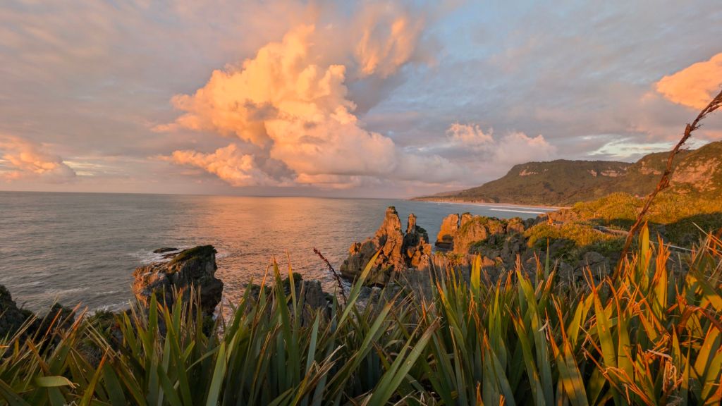
The rock formations, that looked like… well… kind of like a whole bunch of pancake layers stacked on top of each other were fun and different.
I mean, I’d seen similar formations elsewhere, I think inside caves? But it was still cool to see, and what added to the experience were the vivid green colors of the vegetation against the rocks, the sights and sounds of the waves crashing below (Pancake Rocks is right on the ocean, if I didn’t mention that 🙃), and the fact that the sun was setting with beautiful colors beginning to present themselves in the clouds above the watery horizon.
It was also cool because the walkway to the viewpoint of the rocks winds around two different inlets from the ocean itself. One is a long, skinny, deep channel that terminates in going under a small natural and into a big collection pool of water. The other coming the other side of that large collection pool of water I think comes under a much larger natural arch to enter that collection area.
I feel like this is an absolutely terrible way of describing terrain and the scenery before me. 😅
Maybe just imagine a box with really thick sides, and you’re standing at the near corner, the far corners going toward the ocean and the one opposite coming back away from the ocean.
Looking down into the box, it’s just a bunch of water because a channel from your left is bringing water into it, and a channel at the far end is also bringing water into it.
Good golly. I’m just going to add pictures. 😆
I snapped a whole bunch of pictures, because the rocks were beautiful and the sunset was beautiful.
It was a visual feast. 😊
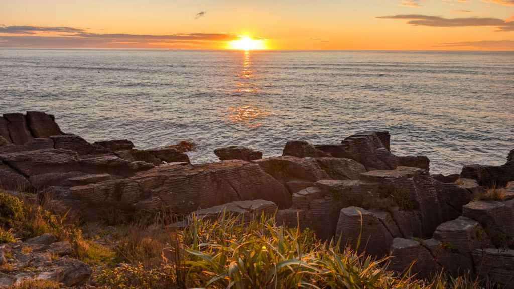
Unfortunately, I left a little too early. I thought the sunset had peaked, the most vivid colors and deepest contrasts having come and gone, but I was wrong!
After walking all the way back to the road to get back to my van, I noticed that the sunset was just getting better and better.
It was stunning. 😍
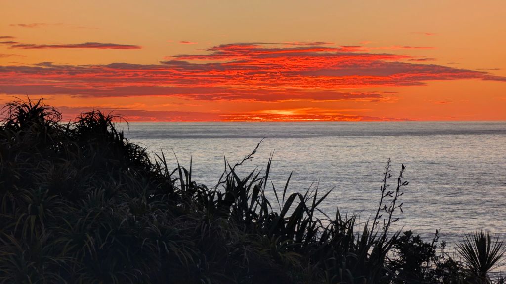
So there on the side of the main road, standing on the top of a fence, I snapped a whole bunch more pictures.
I would have loved to have gotten more pictures in the same area as the first ones I got of the sunset, but my premature exit from the area precluded that opportunity, and I didn’t want to run back, for fear of missing out on the opportunity that I still had to enjoy the view from where I was.
I love this country. There’s so much beauty absolutely everywhere. ☺️
Once the true peak of the sunset had passed, I headed just a tad south, backtracking along the coastal highway, hoping to find an open spot at the nearby freedom camping place, but it was completely full.
So I ended up driving all the way back north to the same one I had stayed at last night on the Fox River.
What a day! Natural beauty. Adventure. Fun stories to tell. 🙏
And then a little bit of veging to finish off the night. 🙃
Lift the world.
Bring it on.
~ stephen
