(written on the 22nd from notes taken previously)
I’ve been dreading writing this entry because of how long I think it’s going to take. 😅
[sigh]
With the day having gone how it went yesterday, I ended up just veging late, having mostly given up on the possibility of making the big hike today.
There was a lot of rain as well, pounding the van a fair bit through the night and morning.
By the time I got up for good, I think it was about 10:00? Despite the lateness of the day, I wondered if maybe I still could make the big hike. 🙃
Would it be smart? I’d be getting such a late start. I’d be in a hurry… again since I had no reasonable way of comfortably staying a night up there (no tent for shelter from wind and rain, no camping pad to keep from getting cold via ground contact.
An up-and-down-in-one-day hike would be 20 miles and might well leave me in the same excruciating pain that the hike did to me last time, where every downward step even a drop of one inch caused wincing pain.
Not to mention I wouldn’t have much time up there to enjoy the view.
I had originally intended to leave around 6:00 or 7:00 in the morning, just after the rain stopped, which would have given me at least a handful of hours to rest and enjoy the view above before having to go back down.
But at this point, best-case scenario would put me at the top with very little time to enjoy the view and likely finishing the hike in the dark.
Not to mention the lack of hydration, nutrition, and sleep I was operating under.
So, naturally, I began leaning toward changing my mind and making the hike. 🙃
😆
That led me to drive over to the car park area to begin preparations, arriving about 10:40.
I hadn’t done much planning prep, since I hadn’t figured I was going to make the trip after my poor decisions yesterday, so I did my best to plan on the fly, packing up bunches of granola bars and apples, slathering peanut butter and honey all over tortillas and sticking them in an empty tortilla bag.
I brought up 3 liters of water via two water-filled 1.5-liter soda bottles and grabbed my water filter bottle (I couldn’t remember if there was sufficient water along the way so as to continuously be able to fill up my filter bottle with creek water and thus not need to bring extra water.).
I packed my rain gear, my thermal bottoms. Couldn’t find any thermal top. Not sure what I did with it? Did I even bring one? Pretty sure I did?
🤷
Grabbed my headlamp, micro john, charging brick and cables, and started shoving food in my mouth and sucking down water. 🙃
I think I ate maybe three? large honey-peanut butter tortilla roll ups.
I don’t remember if I ever said much about the allergic reaction I had a week or two ago? I had three different foods that I don’t normally eat I guess all about the same time. I had a bag of poison cashews, which supposedly had been processed enough to get the urushiol oils out. I had some sweet corn on the cob, and I had honey.
I wasn’t sure if it was the honey or the corn on the cob that caused an allergic reaction on the inside of my mouth (lips feeling weird and the inside of my mouth swelling a little and turning to leather 😅).
I also got symptoms of poison ivy on my lips and… at the other end. 😅
After dealing with the poison ivy symptoms for a good long time, I figured it was time to give the honey a try, and after testing it again, I got no reaction. So either the issue was something to do with the corn on the cob, or the cashews caused two different reactions, the immediate reaction anaphylactic reaction that I’ve never gotten with cashews before, and the normal blistering lips and raw rear end, or the anaphylaxis was a result of something with the corn.
Either way, I don’t have any problem with honey. 🙃
But I did dispose of all of my leftover cashews. 😅
(how on Earth can my body have reactions to processed cashews that have supposedly been cooked long enough so as to render the oils inert? 70%- 85% of the population of this planet is allergic to those oils. Am I just hyper allergic?!?! How are others not getting poison ivy mouth and butt hole like I am? 😶)
Anyway, After shoving a whole bunch of food down my throat and sucking down a whole bunch of liquid in an effort to give my body what it needed to start this huge hike without migraining, I got everything all packed up, locked up the van, and headed out.
11:07 a.m. 😅
I chatted very briefly with a young man who had just returned, and he mentioned that he had taken about 3 and 1/2 hours, I think, to hike down? He said he came down at a pretty brisk pace (and he didn’t say from what portion of the hike he came down the overnight camping area being much closer to the car park than the furthest viewpoint that people generally hike to).
He also said it was pretty muddy. And boy was it ever! 😅
Not 100 meters into the hike, I’d already stepped in a muddy bog (I was wearing my water sandals for the hike. 🙃)
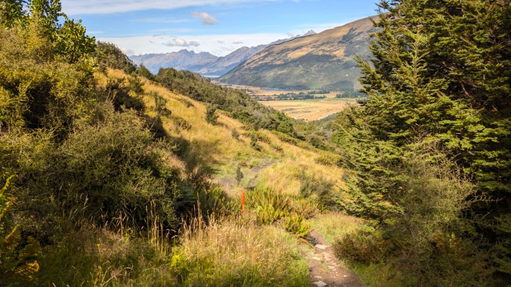
Before entering the forest, one of the signs said that it was a 4 to 6-hour hike, and I think that was just to the main camping area. If I’m remembering correctly, there was another portion of the sign, or maybe a different sign? that said if you went all the way to the end, it was even longer.
I was going to the end. 🙃
Still… I thought maybe I could bust my butt and make it in just a few hours.
I was… overly optimistic. 😅
I remembered the beginning of the hike was steep, and that there was a long down after a steep up, and that’s why I’d pulled the plug at the beginning of the hike last time, not wanting a repeat of the hike we did above Blue Pools.
But oh man was I tired after the first half hour. Legs burning, sucking air… just beat.
With only 2.5 % of the total required hike complete. 😅
Unsurprisingly, thoughts of turning back were quite present… the immediate exhaustion juxtaposed to the lateness of the hour… how far I had yet to go, and The lingering concern of what the excursion might do to my knees.
The hike back down from that ridge at Mount Sealy was painful, and that was only a fifth the total distance this hike required?
😅
Though the rational choice was clearly to head back, onward I went 🙃, regularly checking my map and pedometer and taking the occasional picture.
One of the things that I remembered about the long hike from last time that was reconfirmed this time was that there wasn’t much to see for the first good long time because you were simply walking through forest, so there weren’t many vistas that I felt to stop and take pictures of.
After the first hour (seemingly a miracle to make it that far after what the first half hour did to me!), I had managed to make it more than 2 miles, so I was hopeful that maybe I could make it all the way to the end of the line in four, especially given how steep the beginning was (it was my best guess that it was a 10 mile each way trip).
My recollection had been that after the super steep beginning, it was relatively just a steady upward go for the next… eternity 😅, but nothing crazy. I remember that despite the great distance, I had only stopped to rest a few times in my pursuit of Chase on the previous adventure up.
Of course, part of that was the adrenaline pumping as I sped along trying to catch up to Chase who had a massive head start after I had backtracked and then restarted all the way at the bottom again.
Disappointingly, after two hours, my pace had slowed. 😬
The hike itself was easier, because it wasn’t so steep, but it was also a lot more technical… gazillions of short up-and-down root climbs, bogs to figure out how to cross… all sorts of lovely obstacles to slow one down, and of course the occasional rest and water-bottle fill-up.
Oh, and a side trip up the hill for privacy during a poo break. 🙃
But on I went… hoping my pace might pick up but also being gentle on myself, trying not to go so fast that my steps would put more concussive force on my joints.
It was a bit of a balancing act. A faster pace means your steps land harder, especially on the down climbs 😬
Onward I went, taking as few breaks as I could, passing a couple of girls who had stopped and were sitting on a log eating lunch.
I think you probably already know, but when I’m exercising hard, I don’t want to eat. I guess that’s partly biological (I looked that up later).
But I knew I had to eat, so I force fed myself something like four granola bars as I walked along at a brisk, but not hurried pace.
After the two hours, I had gone I think just under four miles, and after three hours, I had made it just over six, I believe.
I was glad to have made up time during the third hour, but I was still pretty much at a 2 mph pace– definitely not what I had hoped for when starting the hike 😕, but looking back, pretty darn good considering what I was putting my body through and considering how out of shape I am.
I finally broke out of the trees for good at about 6.6 miles into the hike, and I think it was less than a half a mile from that point to the main camping area before the camping-prohibited portion.
I’m pretty sure these are all brand new signs. They looked new, and I don’t remember them from last time. Last time, people were camping all over the place, well up into the bowl area.
But I guess it’s all private property up there, and they allow people to hike into it still, but not camp in it.
Anyway, once I reached the camping area, I saw that people had put their packs down in areas they claimed for camping but had continued on.
That was a smart idea. No sense dragging your pack along with you for the rest of the hike, right?
So I found a little spot to put my pack down, but then I thought… I want to be able to just hang out for a good long time at the best vista, and I don’t want to have to come back because I forgot anything that I might want while just hanging out there.
So I debated… do I leave my stuff here and risk the inconvenience of not having everything with me (and the small possibility someone might steal my stuff), or do I continue on with my pack the additional three miles in (six-mile return)? (which would certainly deplete my energy quicker and would likely increase the possibility of an even more painful return trip)
I put my pack back on, choosing guaranteed convenience over potential future pain. 🙃
Living in a van for so long has spoiled me by always allowing me to have everything with me, and I’ve just gotten used to being able to have everything with me. 🙃
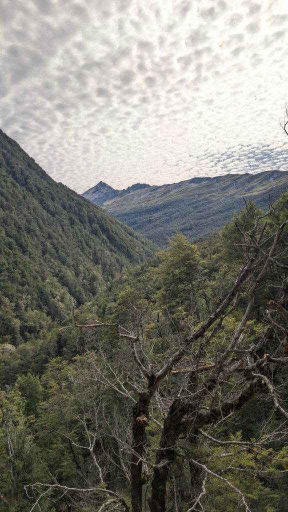
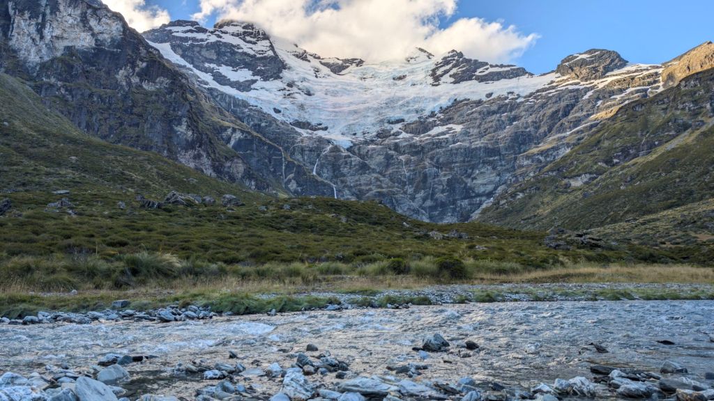
It was about the 7.4 mile mark that the first mostly unobscured view of the towering, waterfall-striped cliff face opened up.
Sadly, my memory built up the view so much that I was a little disappointed by it when I got to that point. I thought I had remembered coming around to bend and seeing the whole thing in its grand majesty.
But there weren’t very many waterfalls that I could see. …at least not compared to what I thought I remembered.
I do remember being absolutely blown away by the view when I came around the bend last time, so maybe I just combined multiple memories into the same memory, thinking that everything I saw throughout the whole hike was all visible at that first grand vista?
Of course, I was still more than 2 and 1/2 mi away from the base of the cliffs themselves, so on I went.
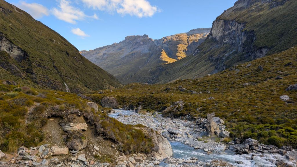
It was about this point in the hike that the trail passed through gazillions of fogs. The valley between the horseshoe shaped Mountain peaks was relatively flat, which made for large areas where the many waterfalls coming down the sides of the mountain created large, unavoidable, muddy bogs.
I had managed to do relatively well on the hike, stepping in bogs only a handful of times, I think, but after trying and trying to avoid the bogs for the last 2 and 1/2 or so miles of the hike, I gave up and just walked right through the muddy messes. 😅
All the rain last night certainly didn’t help reduce the bogginess. 🙃
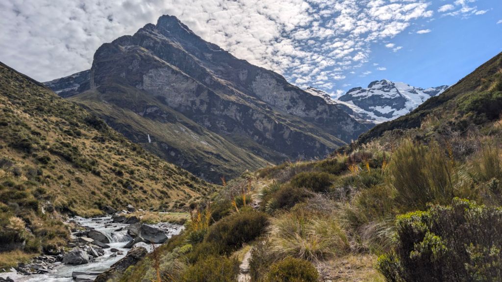
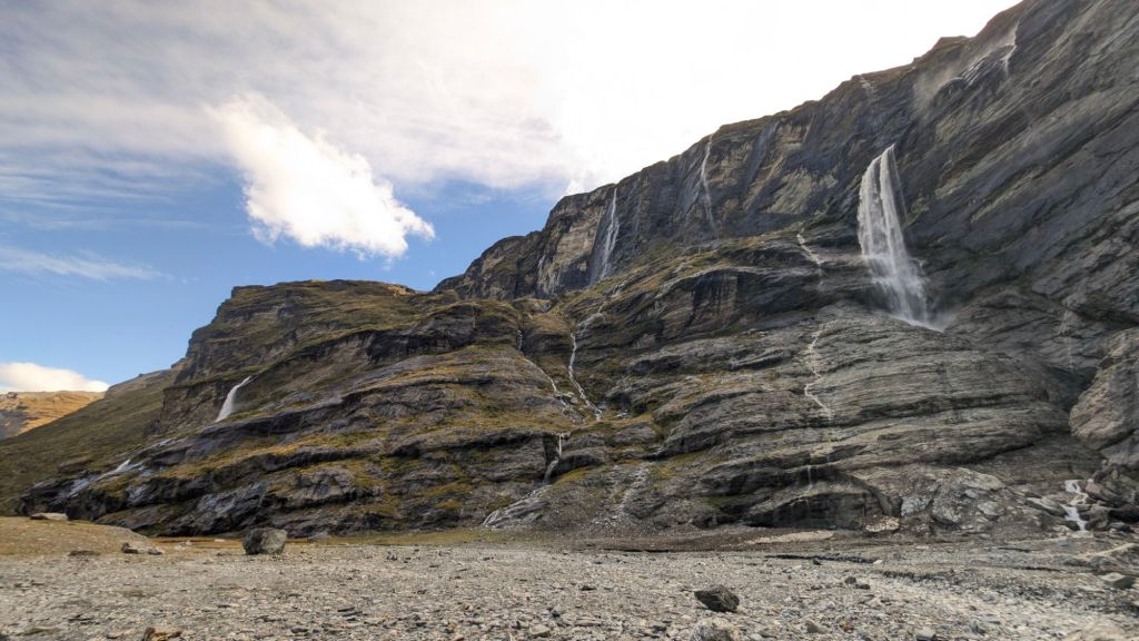
About a half a mile away from the base of the cliffs, there was a large hill in the middle of the valley that I decided to hike up to be able to have the view both looking down and looking up.
By that point in the hike, there were a lot more visible waterfalls. 😁
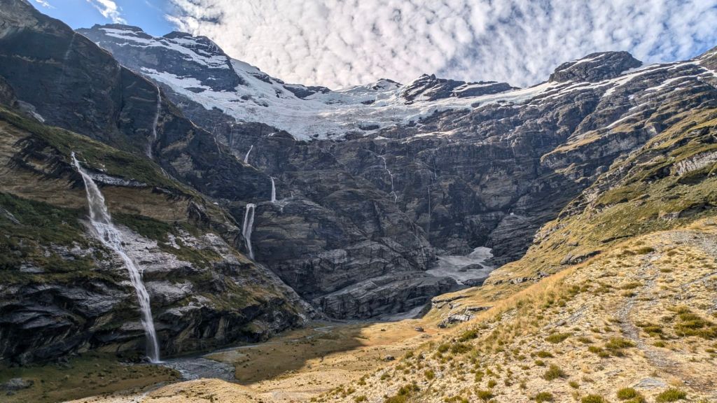
I still don’t think there were as many as there were last time? Despite being two months later in the summer, I’m pretty sure there was a good bit more snow and ice up there this time than there was three years ago, and I think maybe that led to areas where there was ice instead of bare rock, which reduced the number of visible waterfalls because there would have been waterfalls between sections of ice?
🤷
The view was still simply breathtaking. 😊
It was at the top of the overlook hill that I finally sat down to take in and enjoy this long-anticipated view.
9.5 miles of hiking when I’d almost gone back after the first half mile.
And now here I was, again enjoying this magical visual wonderland. 😊
Oh, if only pictures could do this place justice!
But they can’t. They look so… pedestrian compared to the grandeur my eyes were so lucky to behold.
Despite my initial disappointment, this view remains one of my favorite views that I’ve seen on earth. And in a country filled with stunning views, that’s saying a lot. That said, I don’t want to overblow it for anybody and have it be disappointing. It’s certainly not a super colorful vista, and it doesn’t measure up to the CGI-enhanced views from The Rings of Power TV show.
As I sat atop the hill, eating and drinking, I poured out most of the three liters of water that I had brought with me, having managed to stay hydrated with just my filter bottle.
No sense continuing to carry the extra weight that I now knew was unnecessary.
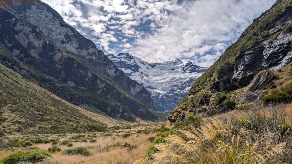
The next question was whether or not I was going to hang out there atop the hill for the rest of my vista experience, or if I was going to finish walking all the way to the base of the cliffs, getting that last half mile in to make it a full 20 miler after return.
I wanted a 20 miler. 🙃
After watching a handful of people arrive by helicopter and hop out to take pictures, after keeping a hawk eye on a very persistent bumblebee, and after forcing a fair bit of water and another four? granola bars down, I made my way down the north side of the Hill, the side closest to the cliffs.
After reaching the bottom of the hill, I spent a little bit of time chatting with a woman from Taiwan whom I’d passed on the hike up. Her name was Lulu, and I forgot to tell her that I had a great great grandma with the same name. 🙃
Cute lady, solo traveler like me, I’d guess maybe 30?
I was pleased with myself when I found that the base of the cliff was just about a perfect 10 miles on the dot from the car park. 🙃
Of course, that self-congratulations also came with a sobering reality: It had taken 5 hours of hiking to get to that point. 😅
And since the longest rest I had on the hike up was my bathroom break, and given that it was a technical hike back, at least some of which was definitely going to be in the dark, it didn’t seem all that likely that I was going to be able to get down much faster than I came up. 😅
Down at the base of the cliffs, I was far too close to them to be able to get good pictures. My eyes can take it all in, but the phone definitely can’t.
As I began walking back, figuring that I would stop again for a little while to just soak in the view, I ran into the two girls that I had passed on the way up who had been eating lunch.
I ended up chatting with one of them for a good little while before continuing my walk back.
Only a few minutes later, I ran into another young lady, I think she’d just turned 30? She was from the states and was a massive world traveler. I think she’d been to something like 60 or 80 countries already.
I chatted with her for another good long time.
With all of my chatting, I probably used up half of my scenery taking-in time staring at the faces of the people I was chatting with. 🙃
I guess I’ll need to do this hike a third time to really feel like I’ve soaked it in. 😆
By the time I finished the last conversation, it was after 6:00, and I had a five-hour hike ahead of me with sundown about 8:30.
Being in a canyon, that meant the darkness would affect me sooner. I was looking at probably at least 2 hours of night time hiking. 😅
Good thing I brought my headlamp and charging brick.
I wasn’t very keen on having to cross all of those bogs again on the way back. Soggy, muddy socks inside velcro sandals makes for a lot of slipping around while walking.
To avoid the bogs, I decided to walk down to the river and just follow it as much as possible.
Worked like a charm. 😁
Sure, I had to cross the freezing-cold, glacier-melt river a gazillion times, risking slipping and falling and getting my phone wet (again), but I was careful, and it was exceedingly more preferable to river walk than to mud bog.
I was also a bit surprised to see a handful of deer. 😊
As I walked back, I felt like I was feeling better than I did at that point of the walk back three years ago. That would certainly make sense, as last time I had walked probably an extra two or more miles by that point and then had jogged the hike, putting a whole lot of extra strain on my knees.
As I checked my pedometer, I found that my heading-back pace was only slightly better than two mph.
It’s tough to go fast and be safe with the technical nature of the hike.
It wasn’t long before I’d made it to 12 mi in the trip and then it was 14.65.
My knees had started hurting, but not as badly as last time. I didn’t know if they were going to eventually hurt that bad, but I tried to step softly as best I could.
I started using my cell phone flashlight I think about 8:30, and probably should have started using it a fair bit earlier.
Eventually, I switched over to my headlamp, keeping it on the lowest setting to conserve battery. Somewhere, let’s just say around the 17-mile mark of the trip, I accidentally took a wrong turn in the dark.
I think I accidentally wandered on to a vermin trapping track.
Gratefully, I found my way back pretty much immediately.
What I didn’t do is learn from my mistake. I think I probably ended up accidentally following trapping track because I had my headlamp on the dim setting, so I couldn’t clearly see the path in front of me and hadn’t thought about there being diverging paths.
That mistake would come back to haunt me.
At about the 18.5-mile mark, less than an hour’s hike from reaching the bottom, knees hurting with every down step, but gratefully, not excruciatingly so, I managed to lose the trail again.
Instead of backtracking (I thought I knew where the trail was), I cut uphill to get back to the path.
But… it wasn’t there.
The underbrush was thick and the hill steep, requiring lots of energy just to go a short distance, both fighting through the vegetation and at the same time using it to pull myself uphill.
It wasn’t long before I realized I had no idea where to go. I didn’t even know where to backtrack to.
I was lost. 😳
I pulled out my cell phone, remembering that Google Maps had a dotted line showing where the trail was, and I hope to orient myself with my GPS location dot in comparison with the dotted line on the map.
Of course… those dotted lines aren’t always, often showing the general location of a trail. 😅
I also had another problem. I’m not sure what causes it, but my previous phones knew which direction I was facing. This phone… it doesn’t get it right, so I can’t just spin in a circle and trust that the direction my phone says I’m pointing is actually the direction I am pointing.
As best I could tell, I needed to go up to get closer to the trail, if it was correctly placed on Google Maps.
So up, up, up I went, through thick brush, up scrambles, and on and on until the forest opened up.
Multiple times, I thought that maybe a break in the undergrowth that I could see up ahead was the trail, but every time I was disappointed.
Every time I checked my maps, it seemed like it was getting absolutely nowhere, perhaps further away from the path, but I couldn’t tell.
Looking at Google Maps, it seemed like I was only a couple hundred feet off the path, but every time I would make another push, I just seemed… further away.
I had been 45 minutes from the car, only a mile and a halfish left to go, and now I was lost in the bush with no idea where the trail was.
By that point, a sense of both devastation and desperation set in, and I continually whined loudly, as if crying but without tears.
I had pushed hard on this hike, but I’d been so smart. I hadn’t rushed. I’d been careful to step lightly as much as possible. I’d forced myself to eat when I didn’t want to. I consistently drank when it was annoying to drink.
I’d worked so hard to do the best I could on this hike, and now I was lost in the woods.
I was exhausted. I just wanted to be done. My left Achilles tendon was hurting. My knees were hurting pretty good, and now this.
Gratefully, I wasn’t actually in danger.
I knew exactly how to get back… just go sideways and the mountain above the river.
Eventually, I’d reach the bottom. I couldn’t actually get lost lost. Just follow the river out.
It was just that I’d already gone 18.5 miles in one day, and I was exhausted, and I was so proud of myself for having made it so far after wanting to give up only a half a mile in.
And now one wrong turn in the dark because I was on the lowest setting of my headlamp, and now I’m bush bashing at 10:30ish in the pitch dark.
As the desperation waned a little, I realized the river sounded really far away. I didn’t remember it sounding that far away, so figured I must be going the wrong direction to find the path.
I had toyed with the idea of just camping out on the mountain for the night until daylight, but I decided to keep going, now heading diagonally both down the hill and down the canyon.
I figured that I would either find the trail or just bush bash the last mile and a half a bit above the river.
Down, down, down I went. The bush gratefully so much thinner (I think because the trees were taller and the canopy thicker because I was so far down the mountain)
And then it happened.
The trail!!! 🥳
After 1/2 mile of bush bashing, and maybe an hour of lost time, I was finally back on the path. I still had pretty much the whole last mile and a half to do, and my knees were hurting with every down step, but oh my goodness. It was so good to be back on a trail. 🙏
And even with the lengthy, tiring detour, my knee pain still hadn’t reached the excruciating. 🙏
Though I had never really been in danger, I was quite cognizant of how easily, in another place, under different circumstances, my navigation mistake and subsequent choices could have cost me my life (as had happened to Celene Cremer, whose remains were finally found a couple of months ago in Tasmania after she went missing in June of 2023).
It was a sobering recognition.
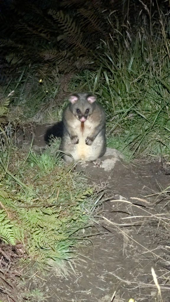
There were lots of Aussie possums on the trail there in that last bit, one of them standing up on its hind legs and just staring at me only a handful of meters away before heading into the bush.
I had forgotten to bring Ibuprofen with me, unfortunately. My sister Heather had recommended it, but I had totally forgotten.
And I was almost back. There was just one last very large uphill that I was not looking forward to, that huge downhill on the way up that had sent me seeking an alternate route three years ago.
Yep. One last big uphill… maybe two or three, but at least one huge one that was going to be exhausting after 20 miles of hiking, but I’m psyching myself up for it.
…
Any time now.
…
Any ti… ummm… am I down?
Wait. Where’s the last big uphill? It’s gotta be any…
I am down!
Wait, what?!?!
I’m down!!! 🥳
I have no idea where that last hill went. I had been anticipating it for a long time. I knew it was there. It had been the death sentence to my first attempt three years ago. And it was certainly annoying to begin the trip this time.
How did I miss it? It couldn’t have been while I was lost because I still had too far to go coming back.
😶
🤷
By the time I got back to my van, gratefully able to avoid that last mud bog that I had stepped in right at the very beginning of my trip today, it was just about 11:15, and I had hiked 20.5 miles.
Wow.
I loaded my stuff up in the van, shoved some food down my throat, took some pain reliever/anti-inflammatory pills, and began the 30-minute drive from the Earnslaw Burn Track car park back to the Chinaman’s Bluff car park, knees throbbing in with pain.
Gratefully, the pills took effect enough to take the edge off the pain, and though the drive back was longer than I’d wanted, I was… home… and I crawled into bed, so grateful to be in bed
Wow.
What. A. Day.
Lift the world.
Bring it on.
~ stephen
